SF speaks for Itself! 會說話的城市(舊金山市區人行道)
一個會說話的城市,拉近了陌生的彼此,溫熱了文化的差異。為旅者與當地人文創造良好的交互作用,提供更友善的旅遊環境給旅者。讓你踩著導遊書旅行!實際的"走過"當地文化與旅遊資訊。本設計在於鼓勵遊客探索富有當地人文色彩/非主流的生活化旅遊路線,避免觀光區因過度集中人潮,而產生畸形的文化變異與重度環境污染。座落在每一個路口的資訊,可降低多數遊客在陌生環境易產生的不安感與文化衝擊。不僅如此,此概念也可與區域商家結合,指引旅客探索當地特色小店,直接幫助在地經濟。降低當地人跟旅客的文化衝突,並且使遊客學習尊重並共享這片土地。
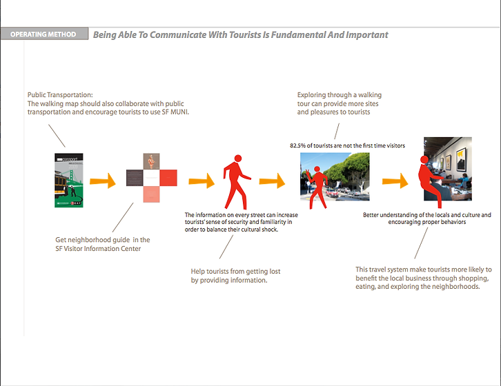
This Design places travel information and local basics on the surface of neighborhood sidewalks, creating maps that you literally walk over. Tourists can easily follow directions and decide their travel paths. People can get this information very simply in 10 to 30 seconds. The design forms a friendlier travel environment for tourists. My idea could encourage tourists to follow the secondary, non-crowded, locally-based travel routes. The information on every street can increase tourists’ sense of security in order to balance their cultural shock. An ongoing message can indirectly remind tourists to act appropriately and be more acceptable. This universal design would easily convince multiple audiences and benefit the local business through make tourists explore neighborhoods. In addition to that, it would also help to form better relation between locals and tourists. The inside aisle is planned to be the path for tourists and visitors, to guide them not to block the sidewalk and to orient them to read the travel information from the right direction. The middle aisle is set to display the main information and content. The outside aisle is scheduled to offer minor and simple content. The new travel experience can make people understand cultural diversities and be tolerant to each nation. My goal is to construct a virtuous cycle for mass tourism, and to make tourists have a better encounter in San Francisco.
A new cycle
for the next Tourism :
SF speaks for Itself!
公共空間旅遊規劃:
會說話的城市(舊金山市區人行道)
TDA-public space-gold prize
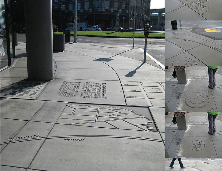
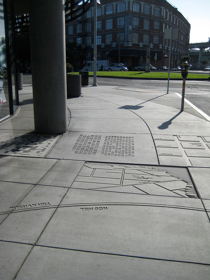
This design suggests that people walk into and “grip” San Francisco city. These cement pieces are placed travel information and local basics on the surface of every sidewalks in main neighborhoods, creating maps that you literally walk over.
讓你踩著導遊書旅行!實際的"走過"當地文化與旅遊資訊。本設計在於鼓勵遊客探索富有當地人文色彩/非主流的生活化旅遊路線,避免觀光區因過度集中人潮,而產生畸形的文化變異與重度環境污染。座落在每一個路口的資訊,可降低多數遊客在陌生環境易產生的不安感與文化衝擊。

cement piece, city map model
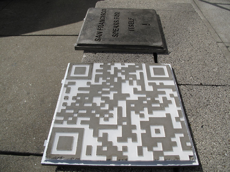
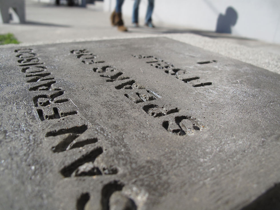
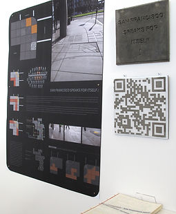
SF tourism website QR code link cement model
font test cement model
The City Narrator Plan, Sidewalk arrangement
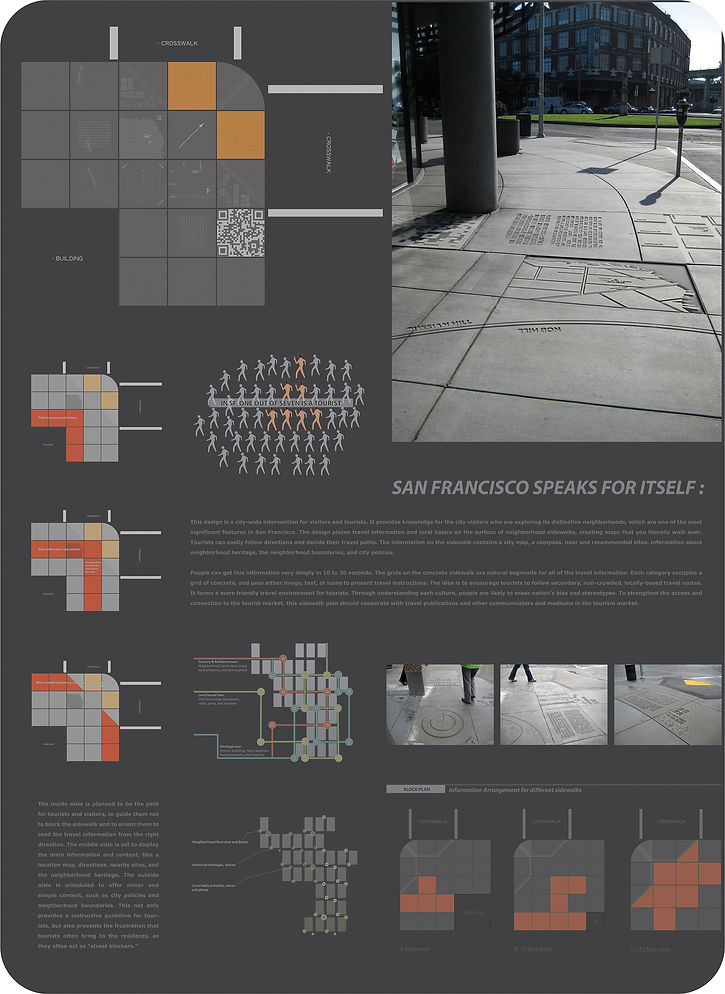
The City Narrator is a city-wide intervention for visitors and tourists. My design provides knowledge for the city visitors who are exploring its distinctive neighborhoods, which are one of the most significant features in San Francisco. While traveling, tourists usually block sidewalks and repeatedly pull out their maps and guides, still without knowing where to go and what to do. The City Narrator places travel information and local basics on the surface of neighborhood sidewalks, creating maps that you literally walk over. Tourists can easily follow directions and decide their travel paths. The information on the sidewalk contains a city map, a compass, near and recommended sites, information about neighborhood heritage, the neighborhood boundaries, and city policies. People can get this information very simply in 10 to 30 seconds.
A New Travel Pattern
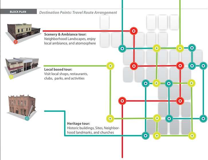
The idea is to encourage tourists to become San Franciscans, and to follow secondary, non-crowded, locally-based travel routes. Besides, tourists tend to be careless, inconsiderate and not conscientious when traveling. Tourists don’t think of the cultural impacts that they bring to the locals. According to my previous interviews and experiments, tourists are likely to ignore posted signs. Some tourists might have difficulties comprehending the foreign language and culture. As a result, an ongoing message that can always be with tourists and indirectly remind them to act appropriately would be more acceptable, understandable, and flexible. A communicative invention can draw people’s attention and more easily convince multiple audiences, so to be universal is an important element in the design development.
The Sketches and Ideation
The sketching process helped me to clarify and determine the key elements which should be embodied in my design concept. I decided that it is important to prevent tourists from getting lost when they are exploring the neighborhoods. The design should form a consistent path to manage tourists’ behaviors and also should be an unremitting message that can educate, remind and inform tourists in a non-stop operation.

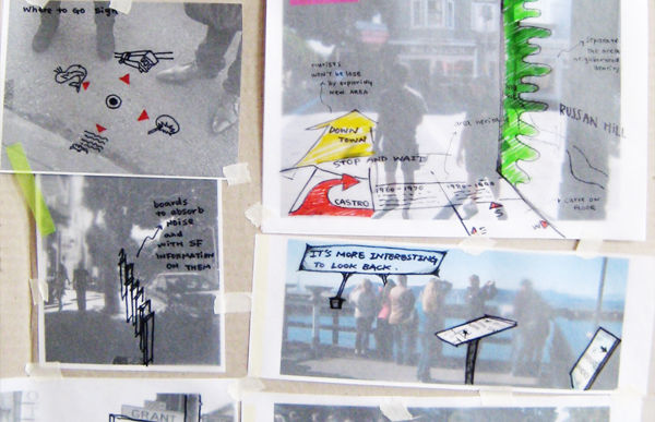
Prototype Testing & Interview
I created a series of transparent layers with images and information, then taped them on the corner of a sidewalk. Besides secretly watching pedestrians’ various reactions, I also interviewed them. In the sidewalk test interview, I asked people: How do you feel about the sign on the ground? How many seconds would you spend on reading this information? Which works better: text, map, or icons? Black-and-white, colored, or both? Is the information enough? Is it easy or hard to understand? Could this encourage people to explore the neighborhood? How would you like it to be improved? Surprisingly, people were really curious and were willing to share their opinions.

Travel by Foot and Explore the city!
The design can highlight the appropriate behaviors and a more accurate impression of the city, in order to encourage tolerance towards tourists’ behaviors and attitudes. It provides alternate tourist routes and enriches tourists’ experiences with additional levels of information and education. Tourists will not only be able to do what they want, but also are educated about local culture, behaviors, and preferences, and have a chance to get to know the city better and enrich their travel. “Go by foot! There is no better way to explore this city.” Despite taking the regular sight-seeing tour buses to “glance” at this city, my design suggests that people walk into and “grip” this city.


Sidewalk info Placement Plan
In order to simplify the use of my design, I rearranged these pieces of information grids and set up a rule of operation for the sidewalk segments. For example, if a sidewalk has three rows of concrete grids, I chose to treat them as an inside aisle (nearest the buildings), a middle aisle, and an outside aisle (nearest the street). The inside aisle is planned to be the path for tourists and visitors, to guide them not to block the sidewalk and to orient them to read the travel information from the right direction. The middle aisle is set to display the main information and content, like a location map, directions, nearby sites, and the neighborhood heritage. The outside aisle is scheduled to offer minor and simple content, such as city policies and neighborhood boundaries. This consistency of content arrangement can standardize tourists’ appearances and behaviors while they are exploring the neighborhoods. This not only provides a instructive guideline for tourists, but also prevents the frustration that tourists often bring to the residents, as they often act as “street blockers.”

concrete sidewalk samples test
The grids on the concrete sidewalk are natural segments for all of the travel information. Each category occupies a grid of concrete, and uses either image, text, or icons to present travel instructions. The information grids are all carved or inserted into the solid concrete.


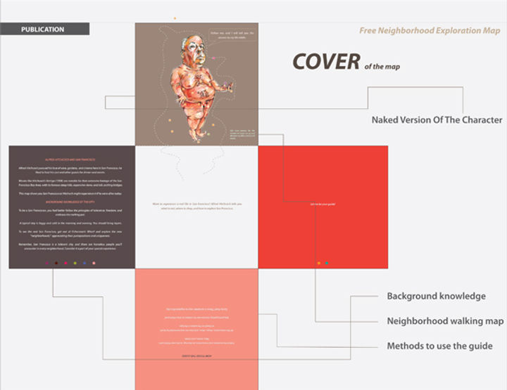

Locals neighborhood Exploring Map
These walking maps use well-known people who lived or related to San Francisco to embed the city’s perspectives, life habits, and basics. An ideal travel scenario is to have local friends who can show you around the city, especially its ordinary life and its distinctive culture. All the travel information and resources such as restaurants, shops, views, and sites, are all recommended by locals or based on the real lives of the characters. Each “San Franciscan” indicates one kind of lifestyle and neighborhood. The free neighborhood travel handbooks can encourage tourists to collect and discover diverse San Franciscan lives by bringing the tourists into the city. These neighborhood guides incorporate several parts, including instructions, neighborhood stories and background knowledge, maps, recommended travel routes, famous sites, shopping information, and images of the best landscapes in the neighborhoods. By encouraging tourists to explore by foot, tourists are able to get a closer look at this city. Tourists can follow the character’s path, which is represented by the numbers and instructions on the map, to discover the character’s likes, tastes, and needs. By doing so, they can mimic customs, attitudes, tastes, likes and behaviors of the celebrities through shopping, eating, watching, visiting specific stores, restaurants, clubs, museums, etc. To engage them more, tourists can ask participating store owners for stickers to dress a nude version of the character on their free guide. The idea can also collaborate with local museums, theaters, and public transportation in order to encourage people to explore the secondary sites. After tourists finish their neighborhood adventures, the guide can be cut and folded into a little paper square statue as a souvenir of their memorable travel experiences.

A Better Cycle for Tourism
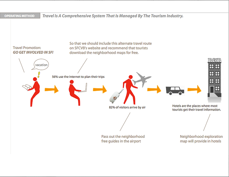
This travel system make tourists more likely to benefit the local business through shopping, eating, and exploring the neighborhoods. After completing their trips with good feelings and informative experiences, they would recommend the exploring tour to their friends and families. Hopefully, people will promote and share the new experiences that they had in San Francisco by posting pictures and publishing their travel blogs right after their trips. In addition to bringing more business to the city and helping tourists to have a better understanding of the local cultures, as well as encouraging proper behaviors. This design strategy will also help to form a better relationship between locals and tourists.